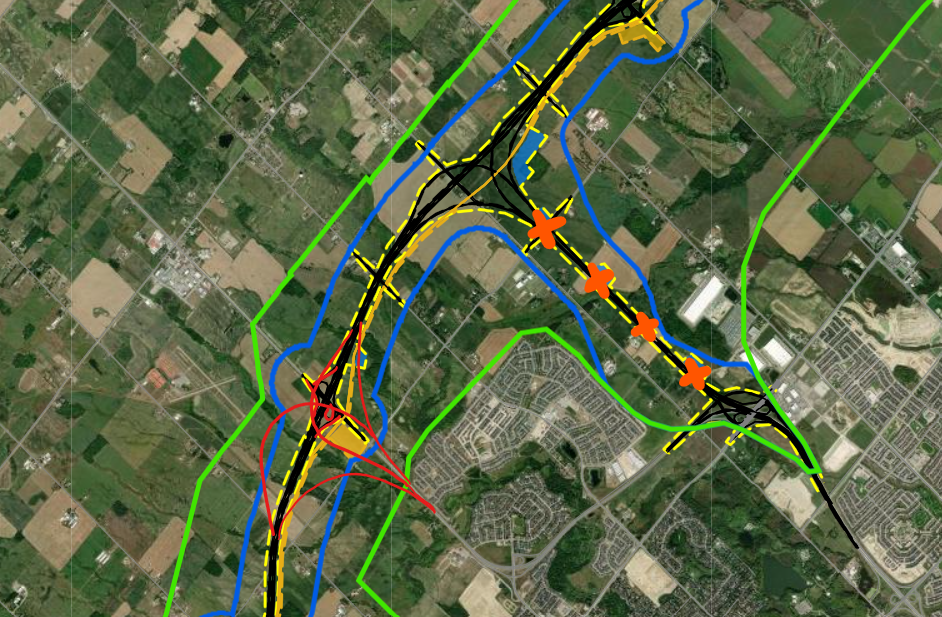
The Hwy 413 map has been the focal point of much debate and discussion, especially for those living in Ontario. The new highway project, which promises to offer a new route through the Greater Toronto Area (GTA), is expected to have significant impacts on commuting patterns, infrastructure, and the environment. This article will explore everything you need to know about the Hwy 413 map, including the routes it will cover, the benefits it aims to provide, and the challenges it poses to the region.
What is the Hwy 413?
The Purpose of the Hwy 413
The Hwy 413 project, officially known as the “Ontario Highway 413,” is a proposed 400-series highway in Ontario that would run through key areas in the Greater Toronto Area (GTA). The road is expected to ease traffic congestion on existing highways and provide a new, efficient route for travelers. As with many new infrastructural projects, the Hwy 413 map has been released to offer a clear visualization of the highway’s potential path.
This highway, once completed, is set to connect some of the busiest regions in Ontario, including Vaughan, Brampton, and Milton. In this article, we’ll take a closer look at the Hwy 413 map, its route, and what the highway will mean for drivers, the economy, and the environment.

Route Overview: A Look at the Hwy 413 Map
The Hwy 413 is planned to span approximately 60 kilometers, cutting across the northern GTA. According to the Hwy 413 map, the highway would extend from the Highway 400 corridor near Vaughan, southward toward Milton, linking with Highway 401. The proposed highway is designed to alleviate traffic congestion, particularly in the region where commuters currently face long delays on highways like the 401 and 407.
The route is expected to follow a path through several communities, including Vaughan, Brampton, and Halton, with numerous interchanges along the way. The Hwy 413 map highlights the importance of these connections, as it will offer alternative routes for commuters who currently have limited options.
Benefits of the Hwy 413
Improved Traffic Flow
One of the main advantages of the Hwy 413 map is its potential to improve traffic flow. For years, residents and commuters in the GTA have dealt with severe traffic congestion on highways like the 401, which is one of the busiest highways in North America. By providing an alternative route, the Hwy 413 is expected to reduce bottlenecks and shorten travel times for thousands of drivers.
The addition of the highway could also ease congestion for local roads, as commuters who currently use smaller, congested routes will have the option of taking the new highway instead. This will help spread traffic more evenly across the region, improving the efficiency of the entire road network.
Economic Growth and Development
The Hwy 413 map also highlights the highway’s potential to stimulate economic growth. By improving access to key regions such as Vaughan and Milton, the highway could attract new businesses and foster job creation. These areas, particularly Vaughan, have already seen significant development over the past few years, with new commercial and residential projects taking shape. The Hwy 413 would further enhance this growth, providing faster connections to other parts of Ontario and beyond.
In addition to fostering local economic growth, the Hwy 413 is expected to be a crucial link in Ontario’s transportation infrastructure. Its location in proximity to major trade routes and Ontario’s industrial centers makes it an essential artery for the movement of goods, services, and labor.
Environmental Impact
Despite the many benefits, the Hwy 413 has also raised concerns about its environmental impact. Critics argue that building a new highway could harm local ecosystems and natural habitats, particularly in areas that are already home to sensitive wildlife and plant species. The Hwy 413 map has been scrutinized by environmental groups, who worry that the highway’s construction could contribute to urban sprawl, increased pollution, and the destruction of valuable green spaces.
On the other hand, proponents argue that the highway’s design incorporates environmentally-friendly measures to minimize damage to the surrounding areas. Additionally, by reducing congestion and facilitating smoother traffic flow, the highway could decrease overall emissions and air pollution, particularly from idling vehicles in traffic.
Hwy 413 vs. Other GTA Highways: A Comparison
Highway 401: The Major Artery of the GTA
The Hwy 413 map is often discussed in comparison with other major highways in the region, particularly Highway 401. As one of the busiest highways in the world, Highway 401 serves as the backbone of the transportation network in southern Ontario. However, its high volume of traffic has resulted in chronic congestion, especially during rush hours.
While the 401 remains a vital route, the Hwy 413 is expected to alleviate some of the pressure on the 401 by offering an alternative route for travelers. The highway’s alignment, which cuts across the northern GTA, aims to bypass the most congested areas on the 401 and provide a faster route for travelers heading east or west.
Highway 407: The Toll Route Alternative
Another important comparison for the Hwy 413 map is Highway 407, a toll route that runs parallel to the 401. Highway 407 provides a faster alternative to the 401 for drivers willing to pay a toll. However, it can be expensive for daily commuters, which has led to concerns about its affordability.
The Hwy 413 is expected to provide a lower-cost alternative to the 407 while offering similar benefits in terms of reducing travel times. The 413 may be particularly attractive to drivers who want to avoid the higher costs associated with toll roads.
Highway 400: Linking to Key Areas in the North
Another important aspect of the Hwy 413 is its connection to Highway 400, a critical north-south route in Ontario. By linking to the 400, the Hwy 413 creates a seamless connection between the northern and southern parts of the province, which is expected to benefit both commuters and businesses. This connection is particularly important for long-distance travelers and freight transportation, making it easier to move goods between the north and the GTA.
The Future of the Hwy 413: What Lies Ahead?
Timeline for Completion
The timeline for the Hwy 413 remains a topic of ongoing discussion. While the highway is still in its planning stages, the Ontario government has expressed its commitment to moving forward with the project. The Hwy 413 map has been finalized, and environmental assessments and consultations with stakeholders are expected to continue.
The construction phase of the project will likely span several years, with the highway expected to open in phases. Once completed, the Hwy 413 is expected to transform transportation in the Greater Toronto Area, offering significant improvements to both commuter and freight travel.
Public Support and Opposition
The Hwy 413 has garnered significant attention from both supporters and detractors. Proponents argue that the highway will provide much-needed relief for traffic congestion, boost the local economy, and improve regional mobility. On the other hand, critics contend that the environmental and financial costs of building the highway may outweigh its benefits, with concerns about its impact on local ecosystems and the increasing urban sprawl.
Despite the controversy, the Hwy 413 remains a key project for Ontario’s transportation future, and it is likely to play a significant role in shaping the region’s infrastructure for years to come.
Conclusion: The Hwy 413 Map and Its Impact on Ontario’s Transportation Landscape
In conclusion, the Hwy 413 map is a crucial part of understanding Ontario’s evolving transportation infrastructure. Whether you are a commuter, business owner, or environmentalist, the highway promises to bring both benefits and challenges to the Greater Toronto Area. By providing a new route that connects key regions, the Hwy 413 has the potential to ease congestion, stimulate economic growth, and provide drivers with more options on the road.
As the project moves forward, it will continue to spark discussions and debates about its costs, benefits, and impacts. However, one thing is certain—the Hwy 413 map will shape the future of Ontario’s transportation network, and its effects will be felt for generations to come.


